

Activités


Suggested itineraries
HIKING: Lake of the 9 Colours - Tête de la Frema - 1 stage on the crossing of the Alps, Larche-Briançon
SKIING: Tour of the Brec de Chambeyron - Pointe d'Aval - Crossings to Maljasset, Larche, Val Maïra
+ on sud.alpes-refuges.fr
MOUNTAIN BIKING
PARAGLIDING
FISHING
BULLER, SE RESSOURCER...
Vous pouvez venir... ne "rien" faire, si ce n'est regarder, écouter, sentir...profiter de la beauté des lieux.
Vous pouvez venir... dormir.
Vous pouvez venir... passer un moment sympa au refuge en famille, entre copains ou avec vous-même.
Vous pouvez venir... rencontrer l'équipe du refuge.
Vous pouvez venir... augmenter votre taux de globules rouges.
Et si vous voulez en faire un peu plus, lisez les quelques idées ci-dessous.
HIKES

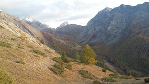
Access to the mountain hut
From fouillouse, cross the hamlet and take the pathway on the left just at the exit of the village. After a steep climb of around 1 hour 30 minutes, the slope subsides till you reach the hut which you will see only at the end.
Duration: 2 hours 30 minutes
Difficulty level: Easy
Lac des 9 couleurs (lake of 9 colours)
An easy walk of 1 hour from the mountain hut that allows you to access the iconic lake of 9 colours situated in the midst of the highest peaks of the valley.
Duration: 1 hour
Difficulty level: easy

tour du brec du chambeyron (Tour of brec du Chambeyron)
A full day hike to return to Fouillouse passing through Italy.
Duration: 6 hours
Difficulty level: Medium
ALPINISM
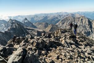
BREC DE CHAMBEYRON
A fairly hard climb, a helmet is obligatory which allows you to reach the peak, from where you will see a very different appearance.
Difficulty level: Fairly hard

aiguilles du chambeyron (Needles of Chambeyron)
plus haut sommet du département
course présentant peu d'intérêt technique ,en mauvais rocher, pouvant être relevé en faisant la traversée qui présente de plus belles longueurs
durée 8h
difficulté AD
Highest peak of the region
It is not a very technical climb, with bad rocks, which can be made more interesting by traversing more challenging difficulty levels.
Duration: 8 hours
Difficulty level: Fairly hard
ESCALADE

V.T.T. et VELO DE MONTAGNE
PECHE
